About City
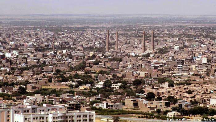
Herāt is the capital of Herat province in Afghanistan. It is the third largest city of Afghanistan, with a population of about 397,456 as of 2006.[1] It is situated in the valley of the Hari River, which flows from the mountains of central Afghanistan to the Karakum Desert in Turkmenistan. The city is linked with Kandahar and Mazar-e-Sharif via highway 1 or the ring road that stretches across the country. It is also linked to the city of Mashad in Iran through the border town of Islam Qala.
Situated in a fertile area, Herāt dates back to the Avestan times and was traditionally known for its wine. The city has a number of historic sites, including the Citadel of Alexander and the Mosallah Complex. During the Middle Ages Herāt became one of the important cities of Khorasan, as it was known as the pearl of Khorasan.[2] It was made independent in 1717 from the Safavid dynasty by the Afghans until 1736 when the Hotaki dynasty was defeated by the Afsharids, which finally became part of the Durrani Empire in 1747. It saw some actions during the 19th century Anglo-Afghan wars. Much of the city has been spared from destructions that occurred in other cities of Afghanistan during the 1978-present wars.
Herāt lies on the ancient trade routes of the Middle East, Central and South Asia. The roads from Herāt to Iran, Turkmenistan, and other parts of Afghanistan are still strategically important. As the gateway to Iran, it collects the highest amount of customs revenue for Afghanistan. The city has an international airport.
History
Reconstruction of Ptolemy's map (2nd century AD) of Aria (Herāt) and neighbouring states by the 15th century German cartographer Nicolaus Germanus
Herat dates back to ancient times, but its exact age remains unknown. During the period of the Achaemenid Empire (ca. 550-330 BC), the surrounding district was known as Haraiva (in Old Persian), and in classical sources the region was correspondingly known as Aria (Areia). In the Zoroastrian Avesta, the district is mentioned as Haroiva. The name of the district and its main town is derived from that of the chief river of the region, the Hari River (Old Iranian Harayu, "Golden Water"), which traverses the district and passes some 5 km (3.1 mi) south of modern Herāt. Hari is mentioned in Sanskrit as yellow or golden color equivalent to Persian Zar meaning Gold (yellow). The naming of a region and its principal town after the main river is a common feature in this part of the world—compare the adjoining districts/rivers/towns of Arachosia and Bactria.
The district Aria of the Persian Achaemenid Empire is mentioned in the provincial lists that are included in various royal inscriptions, for instance, in the Behistun inscription of Darius I (ca. 520 BC). Representatives from the district are depicted in reliefs, e.g., at the royal Achaemenid tombs of Naqsh-e Rustam and Persepolis. They are wearing Scythian-style dress (with a tunic and trousers tucked into high boots) and a twisted Bashlyk that covers their head, chin and neck.
Hamdallah Mustawfi, composer of the 14th century work The Geographical Part of the Nuzhat-al-Qulub writes that:
Herāt was the name of one of the chiefs among the followers of the hero Narīmān, and it was he who first founded the city. After it had fallen to ruin Alexander the Great rebuilt it, and the circuit of its walls was 9000 paces.
Herodotus described Herāt as the bread-basket of Central Asia. At the time of Alexander the Great, Aria was obviously an important district. It was administered by a satrap called Satibarzanes, who was one of the three main Persian officials in the East of the Empire, together with the satrap Bessus of Bactria and Barsaentes of Arachosia. In late 330 BC, Alexander the Great captured the Arian capital that was called Artacoana. The town was rebuilt and the citadel was constructed. It became part of the Seleucid Empire but was captured by Chandragupta Maurya The Great in 305 BC and Become Part of the Mauryan Empire (322 BC-184 BC) after that it became part of the Parthian Empire in 167 BC.
In the Sasanian period (226-652), Harēv is listed in an inscription on the Ka'ba-i Zartosht at Naqsh-e Rustam; and Hariy is mentioned in the Pahlavi catalogue of the provincial capitals of the empire. In around 430, the town is also listed as having a Christian community, with a Nestorian bishop.[6]
In the last two centuries of Sasanian rule, Aria (Herāt) had great strategic importance in the endless wars between the Sasanians, the Chionites and the Hephthalites who had been settled in modern northern Afghanistan since the late 4th century.
Islamization
Further information: Islamic conquest of Afghanistan
http://upload.wikimedia.org/wikipedia/commons/thumb/6/62/Herat_Masjidi_Jami_courtyard.jpg/220px-Herat_Masjidi_Jami_courtyard.jpg
Inside the famous Friday Mosque of Herat or Masjid Jami, which is one of the oldest mosques in Afghanistan.
At the time of the Arab invasion in the middle of the 7th century, the Sasanian central power seemed already largely nominal in the province in contrast with the role of the Hephthalites tribal lords, who were settled in the Herat region and in the neighboring districts, mainly in pastoral Bādghis and in Qohestān. It must be underlined, however, that Herat remained one of the three Sasanian mint centers in the East, the other two being Balkh and Marv. The Hephthalites from Herat and some unidentified Turks opposed the Arab forces in a battle of Qohestān in 651-52 AD, trying to block their advance on Nishāpur, but they were defeated.
When the Arab armies appeared in Khorāsān in the 650s AD, Herāt was counted among the twelve capital towns of the Sasanian Empire. The Arab army under the general command of Ahnaf ibn Qais in its conquest of Khorāsān in 652 seems to have avoided Herāt, but it can be assumed that the city submitted to the Arabs, since shortly afterwards an Arab governor is mentioned there. A treaty was drawn including the regions of Bādghis and Bushanj. As did many other places in Khorāsān, Herāt rebelled and had to be re-conquered several times. In 702 AD Yzid ibn al-Muhallab defeated certain Arab rebels, followers of Ibn al-Ash'ath, and forced them out of Herat. The city was the scene of conflicts between different groups of Muslims and Arab tribes in the disorders leading to the establishment of the Abbasid Caliphate. Herat was also a centre of the followers of Ustadh Sis.
Pearl of Khorasan
Further information: Tahirid Dynasty, Saffarid Dynasty, Ghaznavids, Ghurid Dynasty, Timurid Dynasty, and Safavid Dynasty
The region of Herāt was under the rule of King Nuh III, the seventh of the Samanid line—at the time of Sebük Tigin and his older son, Mahmud of Ghazni. The governor of Herāt was a noble by the name of Faik, who was appointed by Nuh III. It is said that Faik was a powerful, but insubordinate governor of Nuh III; and had been punished by Nuh III. Faik made overtures to Bogra Khan and Ughar Khan of Khorasan. Bogra Khan answered Faik's call, came to Herāt and became its ruler. The Samanids fled, betrayed at the hands of Faik to whom the defence of Herāt had been entrusted by Nuh III. In 994, Nuh III invited Alp Tigin to come to his aid. Alp Tigin, along with Mahmud of Ghazni, defeated Faik and annexed Herāt, Nishapur and Tous.
Herāt was a great trading centre strategically located on trade routes from Mediterranean Sea to India or to China. The city was noted for its textiles during the Abbasid Caliphate, according to many references in the geographers. Herāt also had many learned sons such as Ansārī. The city is described by Estakhri and Ibn Hawqal in the 10th century as a prosperous town surrounded by strong walls with plenty of water sources, extensive suburbs, an inner citadel, a congregational mosque, and four gates, each gate opening to a thriving market place. The government building was outside the city at a distance of about a mile in a place called Khorāsānābād. A church was still visible in the countryside northeast of the town on the road to Balkh, and farther away on a hilltop stood a flourishing fire temple, called Sereshk, or Arshak according to Mustawfi.
Herat was a part of the Taherid dominion in Khorāsān until the rise of the Saffarids in Sistān under Ya'qub-i Laith in 861, who, in 862, started launching raids on Herat before besieging and capturing it on 16 August 867, and again in 872. The Saffarids succeeded in expelling the Taherids from Khorasan in 873.
The Sāmānid dynasty was established in Transoxiana by three brothers, Nuh, Yahyā, and Ahmad. Ahmad Sāmāni opened the way for the Samanid dynasty to the conquest of Khorāsān, including Herāt, which they were to rule for one century. The centralized Samanid administration served as a model for later dynasties. The Samanid power was destroyed in 999 by the Qarakhanids, who were advancing on Transoxiana from the northeast, and by the Ghaznavids, former Samanid retainers, attacking from the southeast.
Sultan Maḥmud of Ghazni officially took control of Khorāsān in 998. Herat was one of the six Ghaznavid mints in the region. In 1040, Herat was captured by the Seljuk Empire. Yet, in 1175, it was captured by the Ghurids of Ghor and then came under the Khawarazm Empire in 1214. According to the account of Mustawfi, Herat flourished especially under the Ghurid dynasty in the 12th century. Mustawfi reported that there were "359 colleges in Herat, 12,000 shops all fully occupied, 6,000 bath-houses; besides caravanserais and mills, also a darwish convent and a fire temple". There were about 444,000 houses occupied by a settled population. The men were described as "warlike and carry arms", and they were Sunni Muslims. The great mosque of Herāt was built by Ghiyas ad-Din Ghori in 1201. In this period Herāt became an important center for the production of metal goods, especially in bronze, often decorated with elaborate inlays in precious metals.
Herāt was invaded and destroyed by Genghis Khan's Mongol army in 1221. The city was destroyed a second time and remained in ruins from 1222 to about 1236. In 1244 a local prince Shams al-Din Kart was named ruler of Herāt by the Mongol governor of Khorāsān and in 1255 he was confirmed in his rule by the founder of the Il-Khan dynasty Hulagu. Shams al-Din founded a new dynasty and his successors, especially Fakhr-al-Din and Ghiyath al-Din, built many mosques and other buildings. The members of this dynasty were great patrons of literature and the arts. By this time Herāt became known as the pearl of Khorasan.
"If any one ask thee which is the pleasantest of cities, Thou mayest answer him aright that it is Herāt. For the world is like the sea, and the province of Khurāsān like a pearl-oyster therein, The city of Herāt being as the pearl in the middle of the oyster."
—Rumi, 1207-1273 A.D.
Timur took Herat in 1380 and he brought the Kartid dynasty to an end a few years later, but the city reached its greatest glory under the Timurid princes, especially Sultan Husayn Bayqara who ruled Herat from 1469 to 912/1506. His chief minister, the poet and author in Persian and Turkish, Mir Ali-Shir Nava'i was a great builder and patron of the arts. Under the Timurids, Herat assumed the role of the main capital of an empire that extended in the West as far as central Persia. As the capital of the Timurid empire, it boasted many fine religious buildings and was famous for its sumptuous court life and musical performance and its tradition of miniature paintings. On the whole, the period was one of relative stability, prosperity, and development of economy and cultural activities. It began with the nomination of Shahrokh, the youngest son of Timur, as governor of Herat in 1397. The reign of Shahrokh in Herat was marked by intense royal patronage, building activities, and promotion of manufacturing and trade, especially through the restoration and enlargement of the Herat’s bāzār. The present Mosalla Complex, and many buildings such as the madrasa of Goharshad, Ali Shir mahāl, many gardens, and others, date from this time. The village of Gazargah, over two km northeast of Herat, contained a shrine which was enlarged and embellished under the Timurids. The tomb of the poet and mystic Khwājah Abdullāh Ansārī (d. 1088), was first rebuilt by Shahrokh about 1425, and other famous men were buried in the shrine area. Herat was shortly captured by Kara Koyunlu between 1458-1459.[14]
In 1507 Herat was occupied by the Uzbeks but after much fighting the city was taken by Shah Isma'il, the founder of the Safavid dynasty, in 1510 and the Shamlu Qizilbash assumed the governorship of the area. Under the Safavids, Herat was again relegated to the position of a provincial capital, albeit one of a particular importance. At the death of Shah Isma'il the Uzbeks again took Herat and held it until Shah Tahmasp retook it in 1528. Several times later for brief periods the Uzbeks held the city but the Safavids ruled it most of the time until the revolt of the Ghilzai and Abdali Afghans in 1716. Several Safavid expeditions to retake the city failed, and the Abdalis remained in possession of the city until 1736 when they submitted to Nader Shah. In 1747 the nephew of Nader Shah, one Aliqoli Khan, revolted in Herat but after Nader's death in that year Herat fell under Afghan rule.
Hotaki dynasty and Durrani Empire
Main articles: Hotaki dynasty and Durrani Empire
Afghan royal soldiers of the Durrani Empire.
From 1725 to 1736 Herat was controlled by the Hotaki dynasty until King Nader Shah's of Persia retook the city. After Nader Shah's death in 1747, Ahmad Shah Durrani took possession of the city and became part of the Durrani Empire. Ahmad Shah Durrani's father, Zaman Khan, was the governor of Herat province before the Ghilzai's conquer of the region. Zaman Khan and several of his family members were killed while his son Ahmad Khan (Durrani) and Zulfiqar Khan were taken as prisoners to Kandahar in the south.
An 1814 map of the Middle East showing Herat when Mahmud Shah Durrani was the ruler in Kabul, Afghanistan.
In 1824, Herat became independent for several years when the Afghan empire was split between the Durranis and the Barakzais. Qajars of Persia tried to take city from the Durranis in 1852 and again in 1856; both times the British helped to repel the Persians, the second time through the Anglo-Persian War. The city fell to Dost Mohammad Khan of the Barakzai dynasty in 1863. Most of the Musallah complex in Herat was cleared in 1885 by the British army to get a good line of sight for their artillery against Russian invaders who never came. This was but one small sidetrack in the Great Game, a century-long conflict between the British Empire and the Russian Empire in 19th century.
In the 1960s, engineers from the United States built Herat Airport, which was used by the Soviet forces during the Democratic Republic of Afghanistan in the 1980s. Even before the Soviet invasion at the end of 1979, there was a substantial presence of Soviet advisors in the city with their families. Between March 10 to 20 in 1979, Afghan army in Herāt under the control of Ismail Khan mutinied. Reprisals by the Afghan government followed, and between 3,000 and 5,000 people were killed. The city itself was recaptured with tanks and airborne forces.
Herāti soldiers in 1879 during the Afghan Revolt
Ismail Khan became the leading mujahideen commander in Herāt. After the departure of the Soviets, he became governor of Herat Province. In September 1995 the city was captured by the Taliban without much resistance, forcing Ismail Khan to flee. However, after the U.S. invasion of Afghanistan, on November 12, 2001, it was liberated from the Taliban by forces loyal to the Northern Alliance and Ismail Khan returned to power (see Battle of Herat). In 2004, Mirwais Sadiq, Aviation Minister of Afghanistan and the son of Ismail Khan, was ambushed and killed in Herāt by a local rival group. More than 200 people were arrested under suspicion of involvement.
http://bits.wikimedia.org/static-1.20wmf5/skins/common/images/magnify-clip.png
An 1879 painting showing the Herat Citadel and surrounding neighborhoods.
Herāt is now fully under the control of Afghanistan's new central government, led by Hamid Karzai, who was initially backed by the United States. The Afghan National Army and the Afghan National Police provide security in the city as well as the whole province. There is also presence of the International Security Assistance Force (ISAF) forces in the area, which is led by Italy and assisting the Military of Afghanistan. Herat was one of the first seven areas that transitioned security responsibility from NATO to Afghanistan. On July 21, 2011, Afghan security forces assumed lead security responsibility from NATO. On the occasion, Minister of Defense Wardak told the audience, “this is our national responsibility to take over our security and defend our country."
Due to their close connection, Iran began investing in the development of Herat's power, economy and education sectors. As a result, the city now enjoys 24-hour electricity, paved roads, and a higher sense of security. In the meantime, the United States is building a consulate in Herat to help further strengthen its relations with Afghanistan. It is currently operating from a renovated hotel for about three years while a permanent location is built. Afghans who apply for visas to the United States will no longer be required to travel all the way to Kabul anymore. Iranian applicants will also use the Herat counsulate because the United States has had no embassy in Iran since 1979. In addition to the usual services, the consulate will be working with the local officials on development projects and with security issues in the region.
Climate
Although Herāt is approximately 240 m (790 ft) lower than Kandahar, the summer climate is more temperate, and the climate throughout the year is far from disagreeable. From May to September, the wind blows from the northwest with great force.
The winter is tolerably mild; snow melts as it falls, and even on the mountains does not lie long. Three years out of four it does not freeze hard enough for the people to store ice. The eastern reaches of the Hari River, including the rapids, are frozen hard in the winter, and people travel on it as on a road.